A SmartSat project quantifying major flood events using advanced satellite technology is seeking to transform the way Australia manages future weather events and provide governments with the tools they need to respond quickly and efficiently in times of crisis.
In Australia, flooding is becoming an increasingly common and devastating phenomena. For example, the March 2021 floods across New South Wales and parts of Queensland acted as a stark reminder of the unpredictability and scale of such natural disasters. These floods, described as a “one-in-100-year event,” has since been followed by a number of equally devastating flood events across the country, including as recently as this month with towns across north Queensland dealing with the realities of receiving a year’s worth of rainfall in a matter of days.
To better manage future flood events, governments need accurate, near-real-time data to map flood extents and assess water volumes for effective resource management. This project, P3.26 Quantifying the Past and Current Major Australian Floods with SAR and Other Satellites, is leveraging Synthetic Aperture Radar (SAR) and optical satellite imagery, collected primarily from the NovaSAR and Sentinel missions, to address time-critical applications.
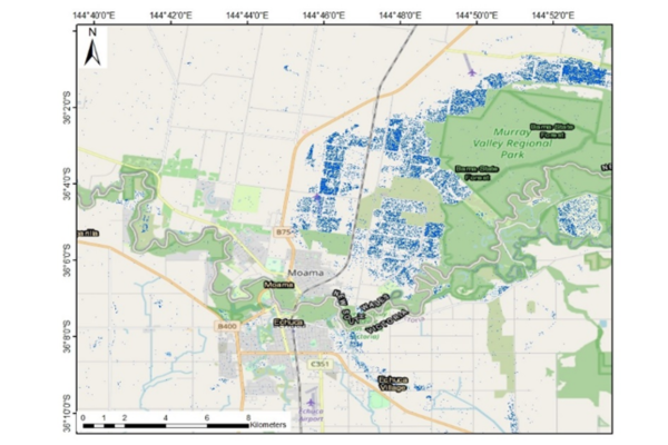 A map around the town of Moama, NSW showing Murray River floodwaters (blue) in October 2022 as calculated by the research project using Sentinel-1 satellite imagery
SAR technology is particularly powerful in these circumstances, due to its ability to see through cloud cover, a critical feature when mapping and monitoring flood events. The research team has developed both 2D and 3D data products, allowing authorities to precisely measure floodwater volumes—critical for managing water resources during and after floods.
SmartSat Research Program Manager, Andrew Barton, praised the project’s collaborative approach.
“This project is an excellent example of how SmartSat’s collaborative research model can bring together the three pillars of end-users, industry, and academic researchers to work together and produce high-value outputs for the nation’s economy and environment.”
“The impact of this project goes beyond Australia, with the potential to position our Earth Observation sector as a global leader in precision flood monitoring technologies.”
This project brings together a research team from the University of New South Wales (UNSW) and Nova Systems, with support from the New South Wales Department of Climate Change, Energy, the Environment and Water (DCCEEW). DCCEEW has provided invaluable data and expertise, addressing gaps and problems with existing systems to monitor flood harvesting of inland water storage sites. Their involvement highlights the significant economic benefits of improved floodwater management, which DCCEEW estimates could result in $100 million in savings per year.
The initial outputs of this project include a software tool which has already been deployed and tested on DCCEEW’s infrastructure, where it is expected to become an integral part of their operational systems for processing 2D flood data. These tools are designed to assist in real-time flood monitoring, ensuring timely and accurate decision-making during flood events. Currently, plans are to incorporate SAR altimetry data to build the 3D capability, which will enhance the precision of floodwater assessments but requires further research.
The project team will also deliver a feasibility study on measuring floodwater depth through satellite altimetry data, an innovative method for quantifying floodwater volume. A comprehensive report on selected case studies from the research is also in progress, offering insights into the practical applications of these satellite technologies in managing floods.
The project complements the AquaWatch program, CSIRO’s mission to deliver a world first ground-to-space water quality monitoring system for Australia and beyond. While AquaWatch primarily looks at water quality and the impacts of pollution, this work fills a critical gap in understanding floodwater quantities and distribution, which in turn affects water quality in rivers, dams, and coastal waters.
As the project progresses, DCCEEW is keen to adopt the SAR analysis pipeline developed by the team and integrate it into their existing processes to further enhance flood management capabilities.