In the carbon farming and Natural Capital sectors, the ability to accurately verify biomass across vast, remote landscapes is a critical operational requirement. For industry partners like RegenCo, monitoring tree canopy across millions of hectares ensures the integrity of carbon portfolios.
Through a collaborative project with RegenCo and SmartSat, the Applied Artificial Intelligence Institute (A²I²) has successfully evaluated and developed Artificial Intelligence solutions to address the industry’s most pressing challenge: the trade-off between measurement precision and spatial scale.
To date, accurate tree canopy assessment has relied on resource-intensive methods, such as aerial LiDAR and field surveys. While these methods provide high-fidelity data, they are cost-prohibitive to deploy frequently across geographically dispersed properties. The industry requires a solution that offers the broad, rapid coverage of satellite Earth Observation while maintaining defensible accuracy for commercial reporting.
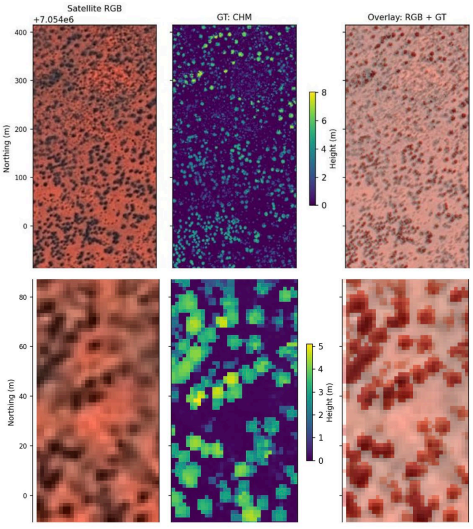
To solve this, the A²I² team developed ResUNet Fusion, a hybrid deep learning architecture designed to detect vegetation in the complex, sparse landscapes of Central Australia.
By combining the robust feature extraction of ResNet with the precise localisation of U-Net, the team created a model capable of distinguishing tree canopy taller than 2 meters from surrounding shrubbery and terrain. This approach was rigorously benchmarked against emerging Vision Transformer architectures and trained using high-resolution LiDAR data as ground truth.
The project delivered three critical insights for operational planning:
- Model Performance
The custom Convolutional Neural Network (CNN) based architecture ResUNet Fusion consistently outperformed newer Transformer-based models for this specific task, proving highly effective at binary segmentation in arid environments.
- Cost-performance optimisation
The research quantified the trade-offs between 1.5m resolution imagery and more accessible 3.0m imagery. Crucially, the study found that image quality often outweighed raw spatial resolution, suggesting that cost-effective data sources are viable for large-scale monitoring if processed correctly.
- Scalable operations
The study confirms that satellite-based AI can provide a scalable, automated metric for canopy extent, enabling a hybrid monitoring framework where satellite data fills the gaps between major physical audits.
The primary outcome of this research is the validation of a hybrid monitoring framework that strategically pairs the scalability of satellite imagery with the precision of traditional methods. While the AI-driven models did not fully replicate the absolute fidelity of aerial LiDAR, they offer a highly effective complementary layer for broad-scale assessment between intensive audits.
This project has provided RegenCo with a clear understanding of the operational boundaries of satellite Earth Observation, specifically highlighting that while the model excels within known environments, performance dips slightly when applied to completely unseen geographical areas. This finding underscores that regional fine-tuning remains a necessary step to ensure maximum accuracy across diverse Australian landscapes.