This exciting SmartSat project investigating the potential of satellite-based thermal monitoring for urban environments is making significant progress in tackling the effects of climate change.
As cities across Australia face the growing challenges that come with rising global temperatures and extreme heat events, this initiative – concentrating primarily on the Adelaide metropolitan region – is evaluating the efficacy of satellite thermal imagery for identifying urban heat islands and understanding their impact.
By exploring a range of cutting-edge space technologies, including data collected by South Australia’s own Kanyini satellite, the project team is aiming to provide partners at the South Australian Department for Environment and Water (DEW) and Green Adelaide with a clear understanding of the options, opportunities and potential solutions for managing urban heat now and into the future.
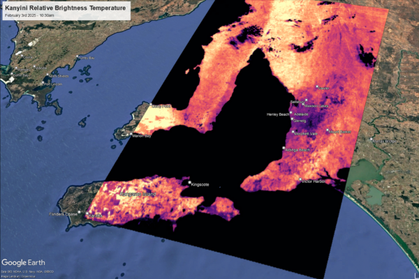 Relative Brightness Temperature (TIR) imagery of South Australia identifying hot spots taken by the HyperScout 2 hyperspectral imager on-board the Kanyini satellite.
The ultimate goal is to provide the evidence they need for improved, data-driven decision-making, especially during critical heatwave events. The project has already achieved several key milestones in our evaluation process:
- Establishing a Ground-Truth Baseline
The team has successfully calibrated their field instruments, including four handheld radiometers and a high-precision Apogee radiometer. These are now being used to collect vital ground-truth data across Adelaide, providing an essential real-world baseline to validate the accuracy of Land Surface Temperature (LST) data from various satellite sources.
- Valuable Insights from Australia’s Kanyini Satellite:
One major highlight has been the successful receipt and initial processing of the first thermal images from the Kanyini satellite. The team has processed two acquisitions over Adelaide, producing geo-referenced products that show the relative brightness temperatures across the city.
- Assessing a Suite of International Satellite Products:
Researchers are now actively evaluating a range of commercial satellite data to build a comprehensive understanding of the available options.
- Hydrosat: the team is analysing daily LST data from Hydrosat’s FusionHub product. While initial comparisons with established Landsat data are encouraging, they have identified challenges related to data gaps caused by cloud cover. The team is engaging directly with Hydrosat to discuss these issues and are preparing to assess data from their newly launched VanZyl-1 satellite to test its capabilities.
- Exploring the Horizon: the researchers have held productive meetings with other leading providers, including Constellr and OroraTech, who will schedule an acquisition later this year, as well as GeoNeon, an Australian company offering an innovative temperature anomaly risk model.
The project team continues to focus on rigorous assessment and demonstrating potential applications for our partners. Upcoming activities include:
- Completing a comprehensive literature review of satellite-based LST monitoring.
- Assessing the accuracy of “predicted” daily LST products from Hydrosat against Bureau of Meteorology (BOM) air temperature data.
- Analyzing the first digital data from Hydrosat’s VanZyl-1 satellite as soon as it is delivered.
- Creating sample daily LST products aggregated to useful administrative boundaries (e.g. ABS Mesh Blocks) to demonstrate the potential of this data for local planning and policy.
Through this detailed evaluation process, this project is building a strong, evidence-based overview of the current and future possibilities for using space technology to create cooler, more resilient urban communities.
Find out more about this project and the team here.