The Oyster Qual Project commenced in mid-2021 led by David Antoine at Curtin University in a partnership with Frontier SI, Myriota, geoplex, GeoScience Australia, Maxima Rock Oyster Company and the Western Australian Agriculture Authority.
The project developed a Proof of Concept and investigated the feasibility of jointly using satellite remote sensing Earth Observation (EO) and in-situ data to assist with identification of suitable shellfish growing sites in Western Australian remote and regional areas (where there is little or no telecommunication connectivity to shore).
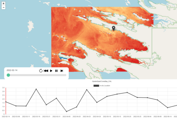 A screenshot of the OysterQual InSitu Data Viewer
This pilot project prototyped a software tool trialled by end-users, to assess whether such a tool could assist them in determining the suitability of future sites for oyster production. The goal was to provide a decision support tool to help narrow down the search space for the best farming locations thus reducing the risk and costs associated with establishing farms at unsuitable locations. To inform site selection, Earth Observation data was utilised for key parameters of interest, including chlorophyll concentration, the total suspended matter concentration, and the associated water transparency.
Now in its final stages, the OysterQual project is poised to deliver tools which include a field deployable solution using advanced in-situ sensors and IoT technology, and a prototype dashboard displaying EO, monitoring data and modelling outputs to stakeholders and oyster farmers. Additionally, the project aims to deliver a decision assistant tool that integrates the modelled data to provide an aquaculture site suitability assessment tool. Further expected outcomes from the project are an economic assessment of scenarios for oyster-farming site selection and a roadmap for future development to evolve the system into an operational solution.