Over five years, SmartSat Cooperative Research Centre (CRC) has taken space-based bushfire research from promising ideas to real operational impact, most visibly through contributions to Digital Earth Australia’s national hotspot monitoring platform, and through a growing pipeline of proof-of-concept demonstrations that are reshaping what is possible.
The Baseline We Are Building From
The Baseline We Are Building From
Not every project in a research portfolio becomes an operational product. That is not failure, it is how research portfolios work. What matters is whether the body of work, taken together, advances the state of knowledge, builds sovereign capability, and creates the conditions for impact at scale. By that measure, SmartSat’s bushfire program has delivered.
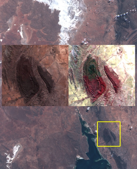 Center Kanyini RGB and false-colour composite (CIR) subset of the Mount Remarkable post-fire burn scar. Caption: ‘Australia’s Kanyini satellite captures post-fire hyperspectral imagery in low Earth orbit.’ Credit: SmartSat CRC / SA Government.
The operational context for all of this work is best exemplified by the Digital Earth Australia (DEA) Hotspots platform, managed by Geoscience Australia. For over two decades, DEA Hotspots has been the backbone of Australia’s satellite fire monitoring capability. It is used by emergency services in every state and territory, is reliable, and is deeply embedded in incident management workflows. The platform draws on both geostationary and polar-orbiting satellite sources: the Himawari-9 geostationary satellite provides near-continuous updates every ten minutes, while polar-orbiting platforms — including NASA‘s Aqua (MODIS) and the Suomi-NPP, NOAA-20, and NOAA-21 satellites (VIIRS) – contribute higher spatial resolution passes two to ten times per day. However, the platform remains the product of a specific generation of technology: revisit cycles ranging from minutes via Himawari’s geostationary coverage to several hours for polar-orbiting sources, ground-based processing with inherent latency, and static detection thresholds challenged by Australia’s landscape diversity.
The question that drove the SmartSat bushfire research portfolio was not whether DEA Hotspots works (it does) but how to close the temporal gap, push intelligence closer to the sensor, and transform a hotspot map into a predictive tool, enhancing the tools emergency managers already trust rather than replacing them.
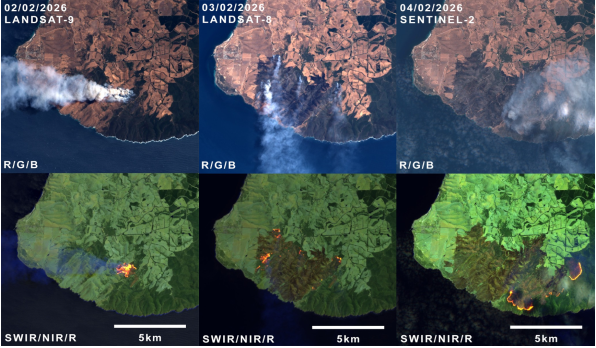 Progression of the Deep Creek bushfire, SA, February 2026 seen through Landsat and Sentinel-2 data. Credit: NASA / USGS Landsat and ESA / Copernicus Sentinel-2. Processed via Digital Earth Australia / SmartSat CRC
A Rapidly Expanding Sensor Environment
The landscape in which SmartSat CRC’s bushfire research operates has shifted dramatically in recent years. In March 2025, OroraTech launched the world’s first dedicated wildfire thermal infrared CubeSat constellation. Eight satellites designed specifically to close the afternoon coverage gap when fire danger peaks and legacy platforms are least available.
By the end of 2025, that fleet had grown to 14 satellites monitoring over 407 million hectares daily, with a January 2026 Kepler Communications partnership enabling onboard processing and optical inter-satellite links, approaching a near-continuous thermal livestream of Earth. Muon Space’s FireSat program, backed by the Earth Fire Alliance, is targeting a 52-satellite constellation with sub-20-minute global revisit times by decade’s end.
This proliferation validates the vision that SmartSat-funded research teams have been building toward: onboard processing, low-latency alerting, and a commercial small satellite infrastructure. It also means the algorithms, validation frameworks, and integration work developed by our researchers are becoming increasing important for the rapidly expanding pool of commercial data that will soon be available to Australian emergency services.
| The Observation Stack | Revisit Time |
|---|
Geostationary (Himawari-9):
Full-disc every 10 min, day/night — DEA Hotspots backbone
Polar-orbiting (VIIRS, MODIS, Landsat, Sentinel-2):
High-res snapshots 1–4×/day — detailed mapping, burn severity
Commercial TIR constellations (OroraTech, FireSat):
Sub-30-min revisit approaching, closing the afternoon gap
AI-enabled CubeSats (Kanyini, Loft Orbital YAM-6):
Alert latency forecast to be single-digit minutes via onboard processing | Legacy polar
4–12 hrs
Commercial TIR (2026)
< 30 min
Modelled onboard AI (P2.38)
< 14 min |
The SmartSat CRC Bushfire Portfolio
Twenty projects and PhD scholarships organised across the full fire lifecycle. Not every thread reaches operational deployment, but each one contributes to the intelligence infrastructure that does. See Table 1 below or read it here.
Where Impact Has Landed
Real-Time Analytics and DEA Integration
This project, led by RMIT University with Geoscience Australia, delivers the portfolio’s most immediate operational outcome. The BRIGHT/AHI algorithm builds on earlier work developed through the Bushfire and Natural Hazards CRC, which established the foundational BRIGHT detection approach. SmartSat funding enabled the team to significantly augment and expand that capability, extending it to the Advanced Himawari Imager (AHI) on Japan’s geostationary Himawari-9 satellite, and introducing dynamic, bioregion-specific calibration against a 30-day rolling temperature history in place of a single national threshold. The result is continent-wide hotspot detection every 10 minutes, processed in under 45 seconds, now integrated into the DEA Hotspots platform. The RMIT research team responsible is now recognised as among the world’s leaders in this field, having been selected as an XPRIZE Wildfire finalist (see below).
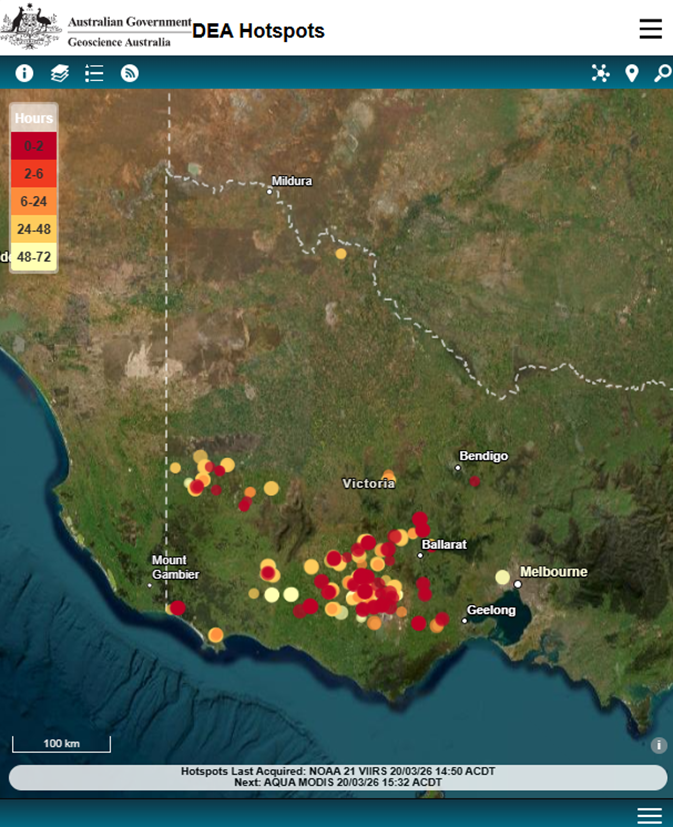 Digital Earth Australia Hotspots (20 March 2026), the operational backbone of satellite-based fire monitoring, updated every 10 minutes using the Advanced Himawari Imager on Japan’s Himawari-9 satellite. Source: Geoscience Australia.
Onboard AI: The P2.38 to P2.61 to SmokeScout Thread
The clearest example of a SmartSat research thread progressing from concept to orbit in a single CRC cycle runs through SmartSat projects P2.38, P2.61, and SmokeScout (P2.64), all led by the University of South Australia*. The P2.38 project asked whether a fire smoke detection model could run within the power and computational constraints of a CubeSat’s onboard processor with sufficient accuracy to be operationally useful. Using simulated HyperScout 2 imagery, the University of South Australia and Swinburne University of Technology research team showed it could. Their Coorong case study modelled an alert latency below 14 minutes, compared to the 20-30 minutes ground-processing pipelines typically require after downlink. Project P2.61 then verified those models against engineering hardware, validating accuracy, speed, and power consumption, crucial steps in the preparation of a flight demonstration.
The SA Space Services Mission, Kanyini, was the intended platform for on-orbit demonstration. The satellite had already contributed meaningfully, acquiring real hyperspectral imagery including a striking false-colour composite of the Mount Remarkable post-fire burn scar, data used directly to train SmokeScout’s algorithms. However, Kanyini encountered a mission failure in early 2025 and with it the ability to support the onboard demonstration. The program responded.
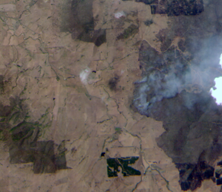
 SmokeScout Phase 1: researchers at the University of Adelaide and Swinburne task Loft Orbital’s YAM-6 to image active fires (CIR image above Deep Creek, SA, 26 Feb 2026) acquiring the real data needed to adapt their AI algorithm for orbit. Phase 2 will see the trained algorithm uploaded directly to YAM-6 for full onboard demonstration. Credit: Loft Orbital / SmartSat CRC.
The SmokeScout project (P2.64) team pivoted to Loft Orbital’s YAM-6, a satellite specifically optimised for high-performance onboard compute whose ‘virtual mission’ architecture allows third-party algorithms to be deployed into orbit without building dedicated hardware.
Since January 2026 the University of Adelaide* and Swinburne team has been tasking YAM-6 to image active Australian bushfires, acquiring the real hyperspectral data needed to adapt and fine-tune algorithms trained in simulation. They are now training the flight version of their algorithm, which will be uploaded to YAM-6 by Loft. That will be followed by an end-to-end demonstration in which the satellite acquires imagery over potential fire locations and runs the full detection pipeline onboard, autonomously, without ground intervention.
As SmartSat’s CEO, Professor Andy Koronios, stated at the partnership announcement, “this demonstration is a vital step; It allows us to refine our detection models and prove the technical feasibility of generating low-latency alerts for fire agencies and emergency services.”
Project P2.66’s extension of onboard AI to thermal infrared for active flame characterisation completes the detection stack.
 SmokeScout Phase 1: researchers at the University of Adelaide and Swinburne task Loft Orbital’s YAM-6 to image active fires (image above Tallagala, VIC, 26 Jan 2026), acquiring the real data needed to adapt their AI algorithm for orbit. Phase 2 will see the trained algorithm uploaded directly to YAM-6 for full onboard demonstration. Credit: Loft Orbital / SmartSat CRC.
All-Weather Coverage, Fuel Mapping, and the Rest of the Stack
Beyond detection, the portfolio addresses the full fire intelligence chain. Project P3.19’s work on synthetic aperture radar provides the all-weather, day-night complement to optical systems, which is critical when the smoke being tracked obscures the fire below. The OzFuel project (P3.24) developed satellite-based eucalypt fuel moisture monitoring, while P4.35 integrates traditional ecological knowledge with Earth Observation-derived fuel data, producing risk assessments neither approach could generate alone. The modelling projects (P2.19s, P3.23, P3.31s) are building the predictive layer through ML-driven fire spread and damage assessment tools trained on real satellite observations. Project P3.27’s multi-platform data fusion closes the loop post-fire, mapping burn severity and tracking vegetation recovery. Project P1.07 addresses the communications failure that compounds every major event, building satellite-enabled resilient emergency comms for when terrestrial networks go down.
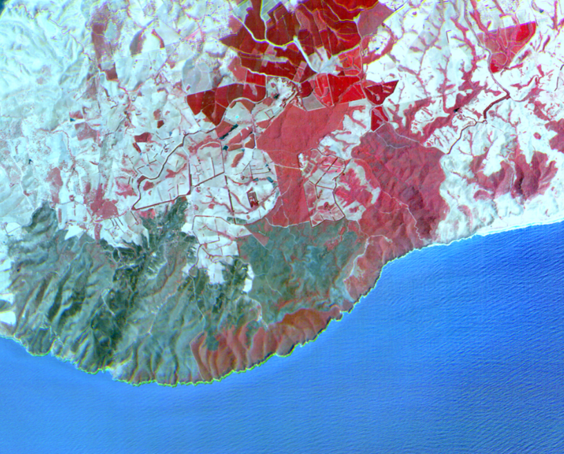
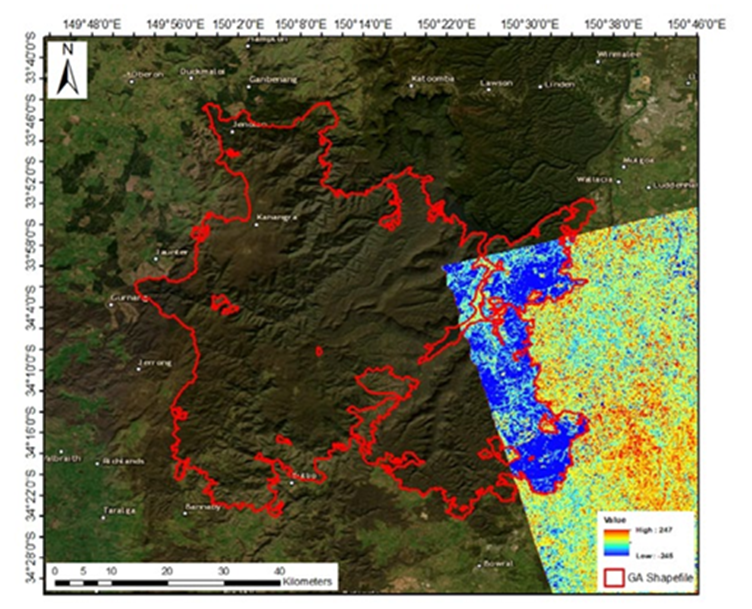 The results from SAR satellite over Green Wattle Creek bushfire area. The coherence difference image from ALOS-2 obtained via the difference operator. (Red perimeter is obtained from GA). Credit: UNSW Sydney / SmartSat CRC.
XPRIZE: Australian Research on the Global Stage
Two Australian-led teams, both linked to SmartSat CRC are finalists in the XPRIZE Wildfire Space-Based Detection & Intelligence track, a US$11 million global competition with finals scheduled for April 2026 in Australia, in partnership with the NSW Rural Fire Service. The prize rules require team to detect all active fires across a state-sized landscape within one minute; characterise them within ten, goals which are highly relevant to SmartSat CRC’s bushfire research portfolio.
🏆 One Australian Finalist — XPRIZE Wildfire, April 2026
Redback Fire Team: RMIT University & Covey Associates Pty Ltd
Already operational in Australia. A two-phase architecture delivers rapid constellation-wide detection within one minute and fire behaviour characterisation within ten, using geographically and seasonally adaptive thresholds built on RMIT’s SmartSat P3.04 research. Hotspot notifications arrive within 20-45 seconds. |
🏆 One UK Finalist with Australian team
SIRIUS Wildfire Alliance: International University Alliance including UNSW Sydney
Integrates EO data, AI, GIS, and wildfire spread modelling across ground and space-edge computing. Designed for minimal false positives and delivers both fire nowcasting and forecasting alongside resource allocation recommendations with contribution from P3.19 research. |
ASII: Carrying the Work Forward
As SmartSat’s Commonwealth funding concludes, the central question is institutional: who sustains the research relationships, brokers the connections between algorithm developers and emergency management end-users, and maintains the sovereign technical expertise that has been built?
The ASII is an independent, not-for-profit organisation, launched in September 2025, established to respond to those needs. ASII’s model is deliberately different from a simply another research centre. It is a connector and co-designer, bridging what CEO, Professor Andy Koronios, describes as the ‘missing middle’ between validated research and deployed solution. For the bushfire domain, that means driving the systems integration that the sector currently lacks: connecting onboard AI alert outputs to incident management platforms, embedding new data streams into existing workflows, and building the institutional architecture that makes cross-agency data sharing routine.
ASII Flagship Program 3
Digital Infrastructure for Disaster Management
This program will establish a globally connected digital infrastructure, powered by satellite, Artificial Intelligence, and advanced communications, to strengthen emergency management and disaster resilience through real-time monitoring, predictive early warning, coordinated response, and informed recovery planning. |
The language of that flagship program is familiar to that of everyone who has worked in this space. What ASII brings is the institutional mandate to act on it. It positions Australian-developed capabilities within global data-sharing architectures built on the European Space Agency, NASA, and Indo-Pacific partnerships established by SmartSat.
The Future We Are Helping Build
Within two to three fire seasons, Australian emergency managers should have access to a substantially richer satellite data environment: DEA Hotspots drawing on commercial TIR constellation data to close the afternoon gap; SmokeScout producing the operational evidence for a follow-on capability decision; and fire spread prediction tools moving from research prototype to operational integration. The interpretable AI work from P2.47s ensures that when these tools generate a forecast, the decision-maker understands why, a prerequisite for operational trust.
Looking further out, a 52-satellite thermal constellation operating at sub-20-minute revisit, combined with onboard processing and optical inter-satellite relay, approaches near-continuous observation. When that environment arrives, the temporal gap that makes fire detection a race against time largely disappears. The constraint shifts from detection latency to analytical capacity,and that is precisely the problem the AI, interpretable modelling, and data fusion research in this portfolio has been preparing for.
Australia is not a passive recipient of this future. The XPRIZE finalists, the DEA Hotspots integration and the SmokeScout on-orbit demonstration on YAM-6 are contributions to a global knowledge commons. The researchers who built them are among the architects of the technical consensus on how space-based fire intelligence should work and ASII is one of the institutions that will ensure that work keeps moving.
A note on cumulative impact
Not every project in this portfolio will produce a tool that emergency managers use directly. Some advanced the evidence base, whilesome trained the researchers who will build the next generation of tools. Some mapped the limits of what is not yet possible, which is its own essential contribution. Collectively, they have established Australia as a credible, innovative, and internationally connected force in space-based disaster resilience. The infrastructure being assembled is not made only of satellites and algorithms. It is made of people, methods, relationships, and demonstrated capability. Every project listed in Table 1 is part of it.
*These projects were completed prior to a merger in 2026 between the University of South Australia and the University of Adelaide to form the Adelaide University.
Fabrice Marre
Senior Earth Observation Specialist

Dr Andrew Barton
Research Program Manager