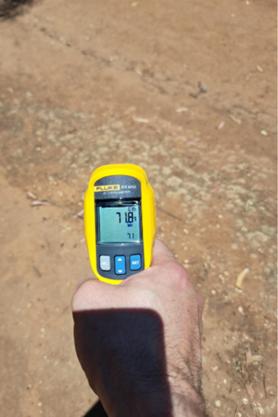
On a sweltering afternoon in North Adelaide, the ground truth campaign was in full swing. At a site ten kilometres away, Flinders University researcher Mike crouched with a handheld radiometer pointed at the surface, logging temperatures that would later be compared against readings from space. In the horse paddocks, Fabrice Marre, Senior Earth Observation Specialist at SmartSat CRC, stood doing the same, radiometer in hand, boots in the dust, the instrument reading 71.8°C off the cracked earth beneath him. The air temperature was punishing, but the ground was something else entirely.
That 71.8°C wasn’t a typo. Land surface temperature (LST), the heat radiating from the ground itself, can soar far beyond what any weather station reports. And it was exactly this kind of reading that satellites orbiting hundreds of kilometres above were simultaneously trying to capture.
 Flinders University Researcher, Michael Hillman, holding a handheld spectrometer during field campaigns in the middle of a satellite overpass.
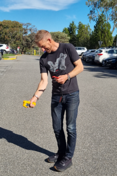
 SmartSat Senior Earth Observation Specialist, Fabrice Marre, holding a handheld spectrometer during field campaigns in the middle of a satellite overpass.
These scenes capture the essence of the Heatwaves: Kanyini Waru project, a SmartSat CRC initiative that set out to answer a deceptively simple question: can satellites reliably map the land surface temperature of our cities during heat waves? The answer, as it turns out, is complicated, promising, and urgently important.
Why this matters, right now
Heat waves are Australia’s deadliest natural hazard. They kill more people than bushfires, floods, and cyclones combined. In Adelaide, three or more consecutive days above 35°C push vulnerable populations, such as the elderly, the very young, the unhoused, and the outdoor workforce into genuine danger. The consequences ripple outward, with hospital emergency departments overflowing, power grids buckling under air conditioning demand, road surfaces softening, and urban vegetation beginning to die — which in turn makes the city even hotter.
Here’s the challenge, however. We can feel the heat, yet we struggle to see it. Air temperature readings from weather stations tell part of the story, but they miss the dramatic variations that exist at street level, the scorching car park versus the cool pocket park, the shadeless concrete plaza versus the tree-lined avenue. When measured from above, LST fills that gap. It reveals the thermal fingerprint of every roof, road, reservoir, and patch of grass across an entire metropolitan area, all captured at a single moment in time.
That capability isn’t just scientifically interesting. It’s the foundation for smarter urban planning, targeted greening programs, better public health responses, and evidence-based climate adaptation. And as major global events increasingly collide with extreme heat, the stakes are rising fast.
The Global Stage: NASA JPL, the LA Olympics, and the Race to Build an Urban Heat Digital Twin
The work being done in Adelaide sits within a rapidly accelerating global effort, one which is about to receive its most high-profile stress test at the Los Angeles 2028 Summer Olympics (LA28).
At NASA’s Jet Propulsion Laboratory (JPL), a team led by scientists including Dr Duane Waliser (most recently the Chief Scientist of JPL’s Earth Science and Technology Directorate) has been working to enhance the societal benefits of NASA’s growing Earth Observation capabilities, with urban heat emerging as one of the most pressing application areas. Waliser’s directorate is responsible for formulating, developing, and operating the remote sensing instruments that underpin NASA’s airborne and satellite Earth science program, and his recent focus has centred on translating observing and modelling capabilities into actionable tools for decision-makers.
The centrepiece of JPL’s urban heat work is ECOSTRESS, the Ecosystem Spaceborne Thermal Radiometer Experiment mounted on the International Space Station. Since its launch in 2018, ECOSTRESS has provided the highest spatial resolution thermal measurements available from space, imaging at 70 metres with the ability to capture cities at different times of day and night. It has now acquired over 620,000 scenes and has been approved for operations through at least 2026, with potential extension to 2029.
More recently, NASA has developed an ECOSTRESS LST Downscaling Tool that uses a random forest machine learning model within Google Earth Engine to sharpen that 70-metre data down to 10-metre resolution (using Sentinel-2), translating satellite observations into street-scale thermal maps suitable for urban planning and extreme heat early warning systems.
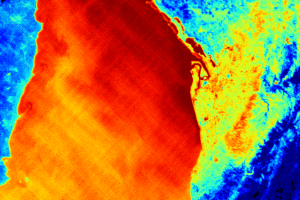 A reading from the ECOSTRESS LST 70m GSD of the Gulf of St Vincent, South Australia taken on 7 February 2026
However, even the best single instrument has its limits. ECOSTRESS revisits any given location roughly once every three to five days, depending on latitude and the space station’s orbital precession. For a city like Los Angeles, preparing to host the Olympics during peak July heat, that means significant gaps in coverage during exactly the periods when continuous monitoring matters most. Landsat 8 and 9 add a few more observations, but cloud cover and orbital timing mean the combined satellite fleet still delivers far fewer usable heat maps than planners and emergency managers need. This is the same temporal gap that SmartSat’s Heatwaves: Kanyini Waru project confronted head-on. No single satellite, or even a small handful, can provide the daily or twice-daily coverage that would enable true real-time urban heat monitoring.
This challenge is driving interest in combining satellite observations with urban heat digital twins, physics-informed computational models that integrate satellite thermal data, weather forecasts, building geometry, land cover, and infrastructure data to create a continuously updated simulation of how heat moves through a city. Rather than relying solely on intermittent satellite snapshots, a digital twin could use each new observation to calibrate and update a running model, filling the gaps between passes with physics-based predictions. The 2028 Olympics represents a uniquely high-stakes proving ground for such an approach.
NASA JPL also operates HyTES, the Hyperspectral Thermal Emission Spectrometer, an airborne imaging instrument with 256 spectral channels in the thermal infrared and a ground resolution of approximately 7 metres. Flown aboard research aircraft, HyTES can provide the high-resolution thermal validation data needed to calibrate satellite products and verify digital twin outputs over targeted areas, exactly the kind of multi-scale, multi-platform approach that the Adelaide project found to be essential.
The practical impact of JPL’s LA-focused thermal work is already visible. Dr Glynn Hulley, a JPL scientist partnered with LA-based NGO, Climate Resolve, to use ECOSTRESS data to target heat-vulnerable neighbourhoods for a ‘cool neighbourhood’ pilot, applying thermal-resistant paint to streets. ECOSTRESS data was used to geolocate and quantify the cooling effect, showing a 5-6°C reduction at street level. That program’s success contributed to a US$350 million California state budget allocation for heat mitigation. Now, as LA28 develops its formal Heat Mitigation Plan (expected by mid-2027) and rolls out thousands of new bus shelters and shade structures, these thermal observation and modelling capabilities will be critical for targeting investments and measuring outcomes.
The relevance for Australia is immediate. Brisbane will host the 2032 Olympics in conditions arguably even more challenging than California, with a humid subtropical climate with summer temperatures routinely exceeding 30°C, humidity above 65%, and extreme UV. Researchers have already published work on optimising sensor networks for urban heat island monitoring at Brisbane’s planned Olympic venues, including the Athletes’ Village at Northshore Hamilton. The digital twin approach being explored for LA could serve as a direct template for Brisbane, and Adelaide’s Heatwaves project has generated exactly the kind of ground-truth evidence base needed to calibrate such systems for Australian cities. The satellite products evaluated, the field validation methods tested, and the hard lessons learned about what works at each resolution scale are all directly transferable. Australia has the opportunity not just to observe what JPL builds for LA, but to contribute to and extend it, from Los Angeles to Brisbane, and ultimately toward a national urban heat monitoring capability.
The Project: Origins and the Kanyini pivot
The Heatwaves: Kanyini Waru project was initiated as a collaboration between SmartSat CRC, Flinders University, Green Adelaide, and the South Australian Department for Environment and Water (DEW). The original plan was ambitious. It involved using thermal data from Australia’s own South Australia-owned Kanyini satellite to produce reliable urban heat maps for Adelaide, supporting heat wave response and urban heat island monitoring.
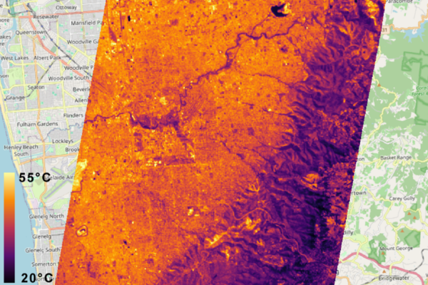
Kanyini, carrying a thermal infrared sensor with a broad 8-14 micron panchromatic band, and two narrower bands (10.05-11.15 micron and 11.45-12.55 micron), did manage to capture some imagery over Adelaide in March 2025. The research team geometrically rectified the data and regressed it against field observations. Some familiar thermal features emerged, with Adelaide Airport showing up as a warm spot, Happy Valley Reservoir as a cool one, the mangroves around St Kilda consistently cool, and the northern plains running hot. But the correlation was weak, with some unrealistic temperature readings in the data. It was a start, but technical challenges ultimately prevented further thermal data capture from Kanyini.
This required a significant pivot. Rather than abandoning the investment, the team refocused on evaluating the best available commercial and public satellite alternatives for urban LST monitoring. The question shifted from “can Kanyini do this?” to “what can we actually use, right now and in the near future, to monitor urban heat from space?”
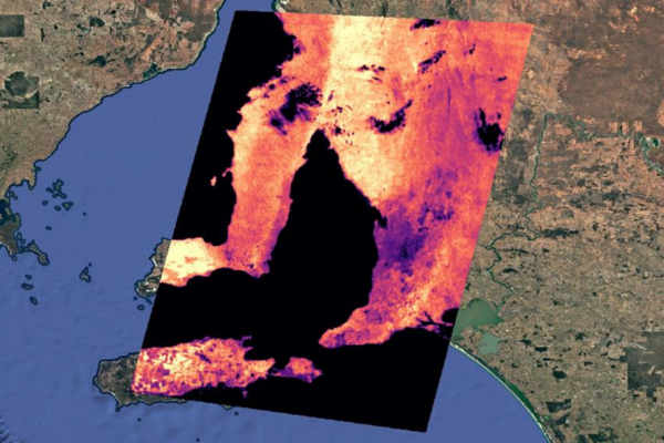 Relative Brightness Temperature (TIR) imagery of South Australia identifying hot spots taken by the HyperScout 2 hyperspectral imager onboard the Kanyini satellite.
The Challenges: Resolution, revisit, and reality
The research team, led by Professor David Bruce and Michael Hillman at Flinders University, systematically evaluated multiple satellite platforms against four critical parameters:
- spatial resolution (how small can we see?);
- temporal resolution (how often can we look?);
- swath width (how much area can we cover at once?); and
- how accurately can we measure LST?
The ideal scenario would be household-scale imagery (5-10 metres), captured twice daily, once in the hottest part of the afternoon and once just before dawn, to capture the full diurnal heating and cooling cycle. The reality fell well short of that ambition, but the journey to understand why proved enormously valuable.
Landsat served as the baseline. It’s free, has decades of historical data, and is well understood. But its native thermal resolution is 100 metres (reprocessed to 30 metres), and its revisit time is 8 days at best. In practice, factoring in cloud cover over Adelaide’s summers, the team found they could only get three or four usable images per summer season. The team also uncovered important quality concerns. Landsat’s uncertainty layers, designed to flag unreliable pixels, frequently produced false positives over urban environments. Large commercial roofs, sharp contrasts between dams and dry land, and even the Adelaide Oval triggered uncertainty flags on otherwise clear days. On a 40°C day with clear skies, applying a 5-degree uncertainty filter would eliminate a significant portion of the urban data. The message we took was to use these quality layers with caution, and always inspect them before applying automated filtering.
Hydrosat’s FusionHub product promised daily LST at 30-metre resolution by blending Landsat observations with MODIS and other sensor data using the StarFM interpolation method. On Landsat overpass days, the correlation was strong. But the team found that the promised daily observations were far from daily, receiving usable data on only about 40% of days in a test month. On non-Landsat days, results were mixed, heavily dependent on the availability of clear-sky data from supporting sensors. The product has since been discontinued as Hydrosat pivoted to building its own satellite constellation.
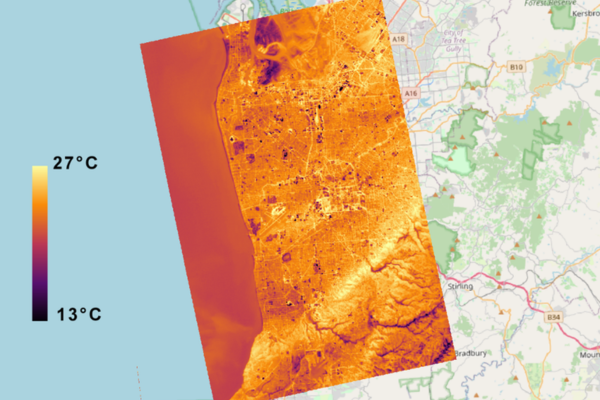
 Constellr daytime LST data over Adelaide, South Australia, captured on 5 January 2026
Constellr delivered something genuinely different. With a native 30-metre thermal resolution (compared to Landsat’s 100 metres reprocessed to 30), the data showed noticeably sharper delineation of individual features, with roads, buildings, and land cover boundaries appearing crisper and more distinct. However, the swath width was much narrower, meaning more images were needed to cover Adelaide’s roughly 90 km × 30 km metropolitan area. The team also observed that Constellr‘s temperature readings ran consistently slightly warmer than Landsat, even on cooler days. With challenges performing coincident field validation, the team couldn’t determine whether this represented greater accuracy or a calibration offset.
What Nighttime Thermal Capture Brings to the Table
One of the most intriguing findings came from Constellr’s nighttime thermal captures. The temperature scale shifted dramatically, with daytime readings typically ranged from 25°C to 50°C, while nighttime data spanned 0°C to 25°C.
The nighttime imagery opened a window into a critical dimension of urban heat that daytime-only monitoring misses entirely. At night, roads and buildings were clearly delineated, retaining heat long after sunset while vegetated areas and water bodies cooled rapidly. The thermal inertia of the built environment as the reason urban areas stay hot while surrounding rural land cools off, was starkly visible.
 Constellr nighttime LST data over Adelaide, South Australia, captured on 23 January 2026
This matters enormously for human health. Research consistently shows that the most dangerous aspect of heat waves is not peak daytime temperature but the failure of nighttime cooling. When overnight temperatures remain elevated, the human body cannot recover from daytime heat stress. Sleep is disrupted, cardiovascular strain accumulates, and vulnerable populations face escalating risk. Councils that have used Green Adelaide’s earlier airborne thermal captures have specifically noted the value of nighttime data for identifying areas where heat persists after dark.
Both daylight and nighttime data also revealed an intriguing artefact, with certain large commercial buildings with shiny, reflective roofs appeared anomalously cold, reading well below ambient temperatures in ways that were clearly unrealistic. This is a known challenge with thermal remote sensing, where highly reflective surfaces can produce misleading readings, and it highlights the need for careful interpretation and quality screening of LST products.
Night capture from satellite remains rare and technically challenging, but Green Adelaide has noted that feedback from councils about the value of nighttime thermal data has been consistently strong. It’s a capability that any future monitoring program should prioritise.
What this project taught us: Perspectives from the partners
One of the most valuable outcomes of this project was the dialogue it generated between researchers and the government agencies who will ultimately use this data. Their perspectives reveal just how much potential satellite thermal monitoring holds and what needs to happen next.
From Green Adelaide’s perspective, the data has clear application. The high-resolution airborne thermal capture conducted in 2022 (costing hundreds of thousands of dollars and requiring five to six separate flying days spread over months due to weather) has served primarily as a communications tool, hosted on a public web map where communities can explore their own neighbourhoods and see the thermal impact of different surfaces. However, Green Adelaide sees an opportunity to move beyond communication into longer-term monitoring using satellite data by using broad-scale Landsat imagery to identify areas of concern, then deploying higher-resolution captures, whether airborne or from satellites like Constellr, over those specific hotspots. This tiered approach avoids spending hundreds of thousands of dollars to capture the entire metropolitan area at maximum resolution when only certain areas warrant that level of scrutiny.
Green Adelaide also emphasised that the project demonstrated that lower-resolution satellite thermal data can still tell a meaningful story. There is a perception among some council partners that only the highest resolution 2-metre airborne data is useful. This project helped dispel that assumption, showing that even at coarser satellite resolutions, the same patterns of urban heat emerge, and the same areas of concern are identifiable.
From DEW’s urban planning perspective, neighbourhood- and block-scale imagery is sufficient and potentially more valuable than chasing the highest possible resolution. For environmental and planning interventions, which are inherently longer-term in nature, the real power lies in the ability to look back in time using satellite archives. New suburbs where trees have been planted (or haven’t), older suburbs where mature trees have been removed as allotments are subdivided, areas that have received greening interventions versus those that haven’t. Satellite thermal data spanning multiple years could reveal what’s actually working to reduce urban heat and provide the evidence base to influence better urban planning.
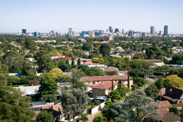 The city of Adelaide viewed from the leafy Eastern suburbs
DEW also identified the critical, relatively uncharted territory of connecting LST data with health outcomes. The real dollar cost of urban heat is primarily a health and worker productivity problem, and the finer temporal resolution needed to track heat wave impacts hour by hour would be most valuable from a public health perspective, territory that hasn’t yet been fully explored in collaboration between environment agencies and SA Health.
From DEW’s policy and monitoring perspective, there is increasing interest at the state level in urban heat as a reportable metric. Urban heat has been included in the department’s environmental report cards, a trend-and-condition monitoring approach tracking whether things are getting better or worse. There is also strong interest from local councils, who have used previous thermal captures operationally to inform where they invest in cooling interventions. The key question from a monitoring standpoint is about temporal consistency, and how reliable and comparable satellite observations taken on different days are under different conditions. The project team suggested that composite or median imagery, fusing multiple observations across a summer season, offers a more robust basis for trend analysis than any single snapshot.
The Path Forward: Building an operational monitoring workflow
The project’s recommendations converge on a practical, staged approach.
- Use Landsat as the foundation. It’s free, it’s consistent, it has decades of archive data, and it covers large areas uniformly. For broad-scale trend analysis and identifying persistent heat hotspots, it remains the most cost-effective option. DEW has already begun working with Landsat thermal data alongside census data on social vulnerability and tree canopy cover to create prioritisation analyses for heat mitigation investment.
- Layer in commercial satellite data where it adds value. Constellr emerged as the most promising commercial option, offering native 30-metre thermal resolution and the potential for nighttime capture. As its constellation grows and costs decrease, it could provide the additional observations needed to fill the temporal gaps between Landsat overpasses, aiming for 15-20 observations per summer to build a meaningful picture of seasonal heat patterns.
- Aggregate to meaningful spatial units. The project demonstrated that aggregating pixel-level data to mesh blocks (the smallest ABS spatial unit, aligned to areas of similar land use) reduces noise, smooths out artefacts, and produces results that are more meaningful for urban planning and management decisions. Individual pixel-level analysis, while scientifically interesting, often reveals noise and quality issues that can undermine confidence in the data.
- Explore value-added products. GeoNeon‘s Heat Susceptibility Index and Heat Exposure Index products, derived from time-series Landsat data combined with ABS social data, show how raw satellite observations can be transformed into actionable planning tools, mapping not just where it’s hot, but who is most exposed and vulnerable.
- Watch the emerging constellations. The commercial thermal satellite landscape is evolving rapidly. Hydrosat‘s VanZyl satellites, SatVu‘s HotSat-2, Constellr’s expanding fleet all represent potential future data sources. The next few years will likely see significant improvements in both spatial and temporal resolution at decreasing cost.
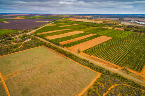 Aerial view of crops in the Riverland, South Australia
Beyond Urban Heat: The wider potential of satellite thermal imagery
While this project focused on urban heat waves, LST data from satellite thermal sensors has applications that extend well beyond city boundaries.
Agricultural water stress monitoring is one of the most developed applications. NASA’s ECOSTRESS instrument was designed specifically to measure plant water stress by detecting the temperature of vegetation canopies, plants under drought stress close their stomata, reduce transpiration, and heat up detectably. Hydrosat has pivoted heavily into this agricultural market. For South Australia’s wine regions, grain belts, and horticultural areas, satellite-derived crop water stress data could optimise irrigation, reduce water waste, and provide early warning of drought-related yield losses.
Fire risk and post-fire monitoring represents another critical application. OroraTech has demonstrated satellite-based fire monitoring using thermal sensors, and ECOSTRESS data has been used to identify pre-fire vegetation stress and post-fire soil temperature patterns that indicate erosion and flash flood risk. With South Australia’s increasing bushfire seasons, the same thermal sensing capabilities being developed for urban heat could serve dual purpose.
Water body monitoring tracking the temperature of reservoirs, rivers, and coastal waters has implications for water quality management, algal bloom prediction, and aquaculture. The project noted that Happy Valley Reservoir consistently appeared as a cool spot in every sensor’s imagery, demonstrating that satellite thermal data can reliably detect water body temperatures.
Infrastructure monitoring is an emerging frontier. Hot road surfaces degrade faster, rail tracks buckle, and power lines sag under extreme heat. Satellite thermal data could potentially identify infrastructure under thermal stress across entire networks simultaneously.
Energy demand forecasting is perhaps the most tantalising application that remains largely unexplored. South Australia’s peak power demand occurs during heat waves, and questions have been raised whether reducing urban surface temperatures could measurably reduce energy consumption. Power companies have historically been reluctant to release consumption data at useful spatial scales, but the theoretical link between LST, air conditioning demand, and grid stress is strong and well-documented in international literature.
What Kanyini taught us and the sovereign capability question
The Kanyini experience, while disappointing in terms of thermal data delivery, was not without value. It demonstrated that even with a broad-band thermal sensor on a small satellite platform, recognisable urban thermal patterns could be detected over Adelaide. It also highlighted the significant technical challenges involved in calibrating thermal instruments in orbit and delivering reliable LST products. The question whether Australia should consider developing sovereign thermal satellite capability, potentially serving urban heat, agricultural, and water monitoring needs simultaneously, remains strategically important. The reliance on commercial international providers for data that informs critical public health and planning decisions carries inherent risks around continuity, cost, and data access. As the thermal constellation market matures, the case for Australian involvement, whether through dedicated missions or hosted payloads, deserves serious consideration.
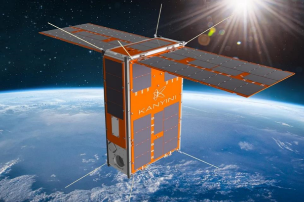 The Kanyini satellite
The Bottom line
The Heatwaves project didn’t deliver the twice-daily, household-scale thermal monitoring that was its original aspiration, no current satellite system can. However, it delivered something arguably more valuable: a clear-eyed, evidence-based assessment of what’s actually available, what works, what doesn’t, and what’s coming. It built the relationships between researchers, government agencies, and end-users that are essential for translating satellite data into real-world impact. It established Adelaide as a proving ground for satellite-based urban heat monitoring methods that could be scaled to cities across Australia, including Brisbane as it prepares for its moment on the world stage in 2032.
With increasing atmospheric temperatures due to global warming, the heat isn’t going away, but the satellites are getting better. The question now is whether we build the operational frameworks to connect the two, turning data from space into informed decision for cooler, safer, more liveable cities on the ground.
Smartsat Project P3.47 Heatwaves: Kanyini Waru was funded by SmartSat CRC through the South Australian Space Industry Centre, with research conducted by Flinders University in partnership with Green Adelaide and the South Australian Department for Environment and Water (DEW).
Fabrice Marre
Senior Earth Observation Specialist