Researchers at Flinders University have just completed a SmartSat research project that has resulted in the development of a novel approach to spectrum sensing from space.
SmartSat Project P1.24 Spectrum Sensing from Space investigated the feasibility of a sovereign, space-based spectrum monitoring capability. The project explored spectrum monitoring technology to determine whether Australia could achieve sufficient improvements in cost and/or capability to justify such an investment.
A key aspect of spectrum monitoring is geolocation (the ability to locate the geographic coordinates of a radio emitter on the Earth) using a novel concept called coherent geolocation (CG). The detection and geolocation of radio frequency (RF) emitters by Low Earth Orbit (LEO) satellites is a capability with broad applications in the National Security, Government and Civil domains. For National Security, this is a key element of an Intelligence, Surveillance and Reconnaissance (ISR) architecture.
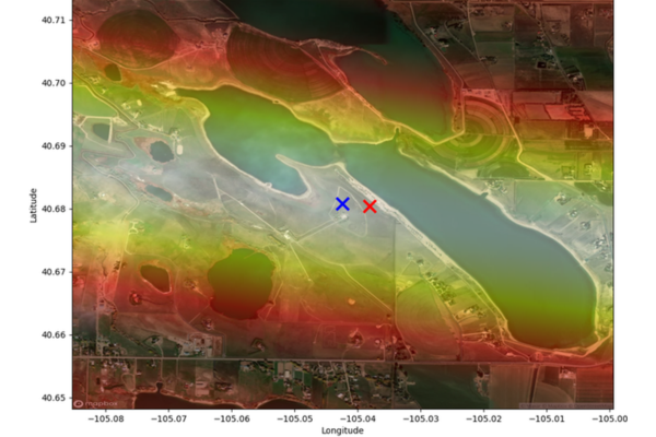 Coherent geolocation of a radio transmitter based on 0.6 seconds of data. The blue cross is the true location, and the red cross is the estimate, with an error of about 200 meters.
Other Federal government agencies require such a capability to administer the use of the radio spectrum by a wide range of users around the nation. Civil applications include law enforcement, search and rescue, asset tracking, agriculture and environmental research. Satellite-based systems are assessed to be the most cost-effective technology for monitoring the electromagnetic spectrum (EMS) across a region the size of Australia.
This technique, developed through this project, exploits the orbital motion of a LEO satellite and the fact most modern emitters produce highly coherent signals. The CG allows users to obtain a geolocation solution and offers benefits in terms of the required quantity and quality of data collection compared with other geolocation techniques.
This project was extended to characterise the performance and robustness of CG using signals collected from space. Phenomena such as measurement noise, emitter modulation, interference, and multi-path propagation were simulated to characterise geolocation performance, and a performance metric was developed for geolocation precision. Because satellite motion creates a long, narrow synthetic aperture, accurate geolocation can be achieved on one axis from a brief data collection. Precision is determined by the quantity and quality of data rather than the size of the synthetic aperture because the emitter is assumed to be a point source.
SmartSat is continuing to work with Flinders University to further develop this novel technique and find utilisation partners from industry. SmartSat CRC and Flinders University would like to acknowledge the significant contribution to this project by the late Dr Jody McKerral, who passed away recently.
Peter Kerr
Defence & National Security Coordinator